Berenike (Egypt)
Temples, dogs and rubbish — the 2010 season in Berenike
University of Delaware–PCMA expedition
Dates:
27 December 2009–15 February 2010 — excavations on the site;
16–28 February 2010 — study season in the SCA archaeological storeroom at Quft
Team:
Co-Directors: Dr. Steven E. Sidebotham (University of Delaware, USA) and Iwona Zych (PCMA)
Archaeologists: Anna Maria Kotarba-Morley (freelance), Piotr Osypiński (freelance), Joanna Rądkowska (ZAŚ PAN PhD candidate), Katya Schorle (University of Oxford, PhD candidate), Marek Woźniak (IAE PAN, PhD candidate), Mary A. Sidebotham, Agata Smilgin and Norman Shelly (archaeology students and volunteers);
Papyrologists: Prof. Roger S. Bagnall (Institute of Advanced Study, New York University), Dr. Rodney Ast (Columbia University, APIS Project head);
Ceramologists: Dr. Roberta Tomber, pottery team head (British Museum, London, Research Fellow), Dr. Tamas Bezeczky (Institute for Studies of Ancient Culture, Austrian Academy of Sciences, Vienna), Ross I. Thomas (freelance), Urszula Wicenciak (Center for Research on the Antiquity of Southeastern Europe, University of Warsaw, PhD candidate)
Geophysicists-archaeologists: Tomasz Herbich (IAE PAN, Warsaw) and Dawid Święch (freelance)
Metal specialist, restorer and artist: Marteen A. Hense (freelance)
Glass specialist: Renata Kucharczyk (PCMA)
Archaeozoologist: Dr. Marta Osypińska (IAE PAN, Poznań)
Archaeobotanist: Assist. Prof. Jarosław Zieliński (Western Pomeranian University of Technology, Szczecin)
Conservator: Katarzyna Lach (freelance)
Registrar/photographer: Jacek Czuszkiewicz (freelance)
Documentalist: Teresa Witkowska (freelance)
Topographer: Łukasz Wojnarowicz (freelance)
SCA inspector-archaeologist: Amer Gad el-Kareem
In 2010 the Polish–American BERENIKE PROJECT took to the field for a first full season of excavations since activities were resumed in 2008. Fieldwork began on January 6 and ran through February 7. A workforce averaging 40-45 Bedouin worked under the supervision of seven archaeologists. Altogether 13 trenches were opened in six sectors of the site; at the end of the season, they were all backfilled, but work in half or so of these trenches will be continued in the future. Specialists stayed on another week to study the different categories of this and last year’s finds. On February 15, a smaller team, including the ceramologists, glass specialist, illustrator and registrar, relocated to Qena in the Nile Valley, meeting up there with the papyrologists to put in a two-week study season at the Supreme Council of Antiquities’ storeroom in Quft.
A new site plan was produced using the existing grid and rechecking the topographical location of all of trenches in order to verify their position on the general site plan. Geophysical prospection continued in three parts of the site, adding to areas already surveyed in 1999, 2008 and 2009, and filling in gaps between previously surveyed parts. The geophysicists walked some 40 km within a few days, covering a combined area of 2.6 ha. So far 9.5 ha, just about half the site, have been mapped [Fig. 1].
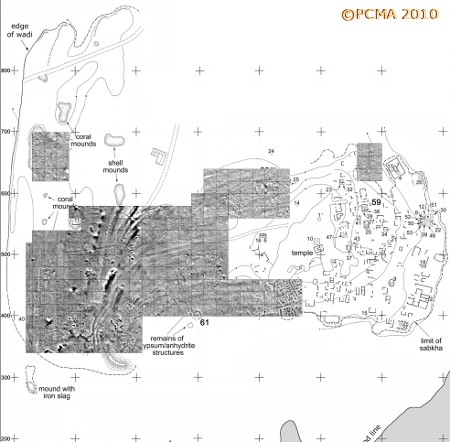
In the western part of the site, which was identified archaeologically as a Ptolemaic industrial district, geomagnetic mapping led to the identification of an architectural complex measuring 50-55 m (EW) by 70 m (NS). Neither the external wall nor the inner walls of the complex are visible on the ground. Architecture was mapped very distinctly also at the southeastern end of the surveyed area, showing a satisfying correspondence with the plan established in the original topographical survey. Nonetheless, the distinctness of the magnetic image, which shows particular walls to the extent that individual buildings and their internal divisions can be recognized, as well as paths (streets?) between the structures, provides reliable data for reconstructing house plans and even identifying doorways between particular rooms. The intervening area of the harbor shows long parallel anomalies that we interpret as banks of the receding waterline inside the harbor basin, formed as the port gradually silted up during its use-life.
Harbor area trenches
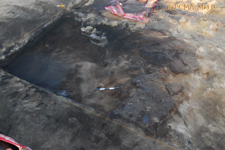
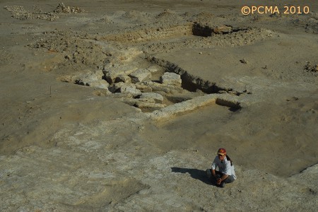
Extension of trench BE09-54 from last year verified the ideas of the excavators concerning the construction of the Early Roman port in the northern part of the crescent-shaped harbor basin [Fig. 2].
The deepest layer reached this year, adjacent to where we expected the late 1st century BC waterline, yielded a large bronze coin of Ptolemy II Philadelphus (reigned 282-246 BC) in very good condition.
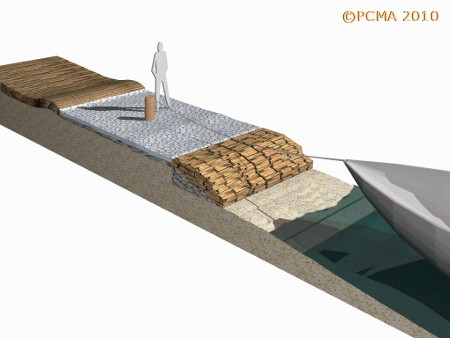
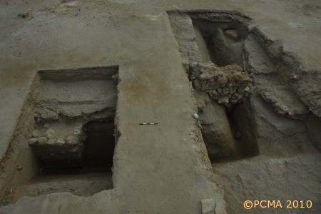
Unexpectedly, however, the team found confirmation of an inverse stratigraphy in the harbor basin with younger remains being found further down and south within the basin. The area directly south of last year’s trench (which had been traced in the northeastern corner of the Early Roman harbor feature as identified in satellite and magnetic images of this part of the site) proved to be part of some shipyards where wooden cedar beams from boats and coils of 5-cm thick mooring ropes — some about 13 m long — had been stored. The shipyards had gone up in smoke some time in the first half of the 2nd century AD, leaving a thick deposit of fine black ash atop the original slope [Figs 3-5].
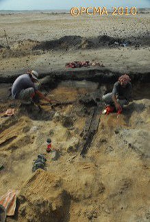
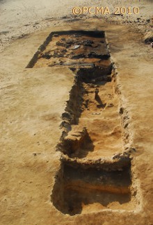
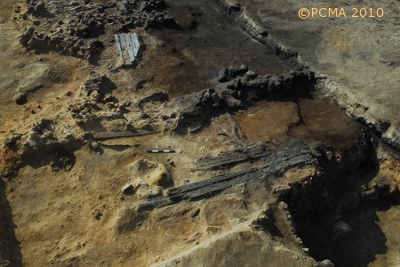
The yards were constructed taking advantage of sloping terrain, their back against the top of a natural coral-rock ridge that formed the core of the eastern Early Roman pier. The fire was less extensive on the rocks higher up, preserving the wooden planks and coiled ropes; the over 3-m long cedar beams at the northern end of the excavated area were found completely charred at the western end. Some of the ship timbers were 3.15 m long and were put together using a mortise-and-tenon technique, one commonly used in the Mediterranean at that time. All the organic remains were extremely fragile, tending to blow away along with the ashes in the strong northerly winds that are common in Berenike. Despite a substantial emergency preservation effort, neither the wood nor the rope could be lifted and had to be studied in the field. After the conflagration the yards appear to have been abandoned and the area was never used again.
In effect, instead of digging a test to the earliest harbor remains, the team concentrated on uncovering the extensive remains of the yards (trenches BE10-54S, BE10-62 and BE10-64 including all intervening baulks). The find is unique considering that so-far no Roman-age remains of this kind have been discovered in the Red Sea coastal area. This work will be continued next season, extending the trench in a southerly and easterly direction, as it is now clear that the yards were constructed with their back against the top of the ridge.
A second trench in the harbor area (BE10-67) was started in a spot where analyses of geomagnetic and satellite images suggested the presence of large structures forming the waterfront in the middle of the crescent-shaped harbor basin. It is to this place that, according to a current working hypothesis, the Early Roman-age port had shifted, abandoning the already useless Ptolemaic installations which had been designed to accommodate big-cargo carriers including elephant ships (elephantegoi). At the end of the season, the damaged tops of two architectural features had been uncovered, running in line with the anomalies shown on the magnetic map. Work will be continued in this trench.
The inverse stratigraphy of the harbor basin was further confirmed when excavations of a trench set up on the visible remains of a structure almost in the center of the harbor basin (BE10-61, south and southeast of the previously described trenches) revealed a temple active from the 4th through 6th century. This is the latest period in the existence of the harbor at Berenike. The temple was raised of coral heads and formed a single rectangular cella, approximately 4 m wide and 8 m long inside the walls [Fig. 6].
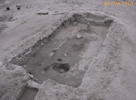
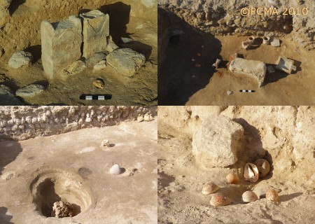
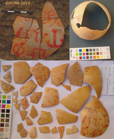
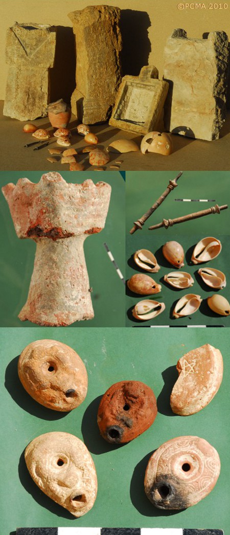
A reused inscribed stone altar [Fig. 7, top right, 10] contained a dedication in Greek to the gods Isis, Tyche and perhaps Sarapis, made by a member of the imperial household in the first year of the Emperor Trajan; this could be indicative of the temple’s dedication. The stone was found reused in a cult offering context with a temple pool next to it, as well as medium-sized cowry shells with holes for suspending and broken-off amphora necks. Another group of offerings consisted of a number of cowry shells, together with a late ‘Frog’-type lamp arranged in a makeshift altar by the temple wall [Fig. 7, bottom right]. Cowry shells were also laid out in the entrance to the temple in the latest phase of its use. Just inside the cella, opposite the entrance, a coral head of truly huge size was found embedded (perhaps in situ) at the bottom of a round pit [Fig. 7, bottom left]. Wooden bowls had been left standing around its perimeter. At the far, northern end of the cella, a column with broken top, about a meter high, was still standing in the middle and strewn around it were the shattered remains of at least two ostrich eggs painted in red with a set of motifs that include a pentagram star and some apparently Greek letters [Fig. 8].
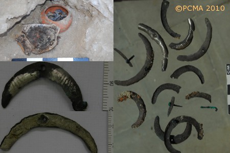
In the northwestern corner, two stone altars had been set up side by side, one of them cut down to match the height of the other altar and propped up with a damaged temple pool. The top of a ‘Frog’ lamp was found in front of the altars, which still preserved remains of a burnt offering on the top [Fig. 7, top left]. Last but not least, an unusual votive offering was found in the layer associated with this phase of use of the harbor temple. Carefully concealed in the southwestern corner of the room there was a small pot with broken-off rim covered with a lid that was the broken base of another pot. It was found undisturbed. Inside it someone had hidden about 50 silver stamped lunula ornaments, each pierced in the middle and some still fitted with small bronze furniture nails (see also below, section on specialist studies) [Fig. 9].
By the end of the season, it became clear that the excavators had not yet reached the original floor of the building as the tops of two rows of benches parallel to the eastern and western interior walls of the cella began to appear. At the same time, it became evident that the late temple stands on the remains of an earlier building executed in a different technique suggestive of the earliest occupation of the site in the Ptolemaic age. Indeed, the back, northern wall of the temple is doubled, the coral-head wall being erected against a wall of regular anhydrite gypsum blocks standing at least three courses high.
Clearing of an extensive patch of decayed rock anhydrite just to the north and west of the temple, in a place where magnetic imaging had revealed another rectangular structure, led to the uncovering — by dint of much sweeping and hacking at the shapeless mass of dissolved anhydrite — of a collapsed wall of big blocks joined by wooden swallow-tail dowels, of exactly the same kind as can be seen in the Serapis temple at the highest point on the site [Fig. 11].
At the present stage of exploration of trench BE10-70, we can be sure of finding a building possibly dating back to the establishment of the Ptolemaic port at Berenike. It also seems evident that this early building, as well as the late temple, stood on an island (possibly a dredge heap, but it is too early to say for sure) in the entrance to the harbor. Its interpretation — whether it was also a temple or perhaps a lighthouse — must wait until further excavations can be carried out in the trench.
The Ptolemaic harbor district west of the harbor
Two trenches (BE10-66 and BE10-69) were dedicated to tracing the course of a V-shaped ditch found originally in a trench from 2001 and interpreted provisionally as the border of an elephant pen [Fig. 12].
While the present research has neither proved nor disproved its interpretation as an elephant pen, the results have confirmed earlier findings concerning the chronology and general character of the occupation in the area. The line of the ditch was followed in later times, but all within a hundred-or-so year period of its establishment, by a low wall which may be connected with the structure imaged on the magnetic maps. It, like the ditch before it, must have been a border wall of the complex and like many fences/walls, had rubbish discarded behind it. This rubbish consisted of large quantities of only two variants of Ptolemaic amphora and a keg form, all from the 2nd century BC. A disc-shaped piece of lead weighing over one kilogram, folded and with a hole pierced through the center [Fig. 13], coming from a nearby trench (BE10-68) which only started to be explored this year, is further proof of industrial activities carried out in this part of the Ptolemaic district.
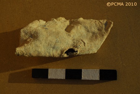
A chance surface discovery just north of the trenches in the western part of the site was identified by the team’s archaeozoologist as remnants of an elephant tooth [Fig. 14].
This is still the sole, tantalizingly palpable evidence of live elephants at the site.
The harbor district northwest of the harbor
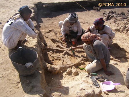
This area north and northwest of the harbor is peppered by coral and shell middens, which likely reflect occupation of whatever harbor district architecture existed back of the crescent-shaped harbor ridge. The ridge even today is a good path connecting different parts of the site; it likely served in this capacity in antiquity. One of the middens in the northwestern part of this area can now be proved to be of Early Roman date, although the reason for digging trenches BE10-63 and BE10-65 was entirely different. The first of these trenches was located in the middle of a big and strong anomaly that defied geophysical interpretation. Nothing to explain the anomaly was found to a depth of 1.30 m, but instead the excavators hit upon a batch of four dog skeletons in close proximity to one another [Fig. 15].
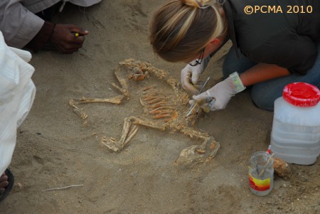
The evidence is not conclusive, but it is possible that the animals were interred intentionally. There were no accompanying finds, but the Early Roman stratum connected with the dog burials could be traced back to a nearby midden, thus dating the midden as well.
Early and Late Roman rubbish dumps
The Early Roman rubbish dump in the northeastern part of the harbor area — long the source of many spectacular finds, including last year’s batch of over 200 ostraca — continued to be explored. It seems, however, that the ostraca-bearing area has slowly been exhausted as this season the hoard was significantly smaller. Nonetheless, the rubbish dump (trenches BE10-58, BE10-60 and baulks between old trenches) provided the usual abundance of organic and non-organic artifacts and ecofacts.
Another rubbish dump was tested in trench BE10-59, which was located amidst abandoned buildings in the late Roman commercial-residential area. It proved to be of late (mainly 5th century) date, like the surrounding architecture, with possible evidence of 6th century contamination on the surface. The only evidence of any kind of architecture was some tumble and a corner block located at a depth of more than 2 m below the surface in the southwestern corner of this 4 by 4 m trench. The accumulation consists of intercalated thin layers and lenses of ashes and the various batches of rubbish that reflect individual depositional events [Fig. 16].
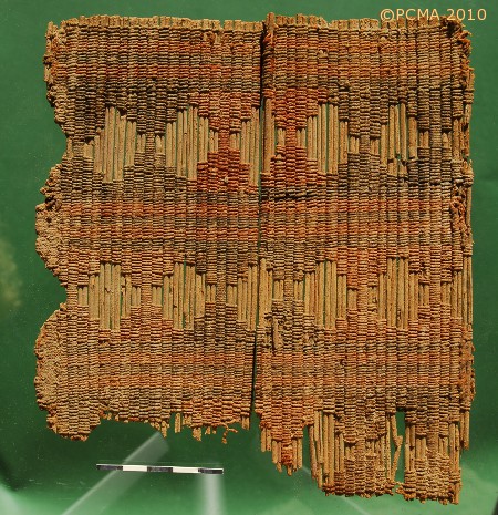
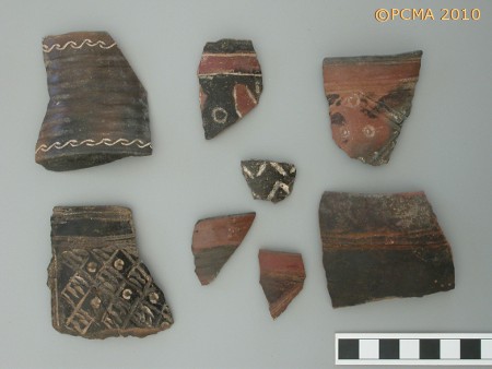
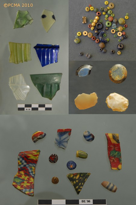
Altogether they form a fairly homogeneous deposit that is suggestive of a workshop in which leather and hides, wood and turtle shell were crafted into objects of ornamental value. The artisan seems to have worked with glass beads, but also with bracelets and pendants and other ornaments of a variety of materials including tortoise shell, ivory, bone, horn, glass, faience, clay, semi-precious stone (including cameo blanks) and even gold in the form of gilded beads [Fig. 18, top right and center]. The trench also yielded a large quantity of pottery in good condition: amphorae, table wares and cooking wares. According to the Project’s ceramologist, the amphorae included many vessels of LR Amphorae 1 from Cilicia/Cyprus, LR3 vessels from the region of Ephesus and Nile amphorae. Finewares were primarily from Aswan. Pottery from outside the Roman Empire included turquoise glazed table wares and coarse-ware transport containers from Mesopotamia and handmade Aksumite pottery from Ethiopia. Other pottery from outside the Empire could not be closely sourced. Local handmade pottery, known as ‘Eastern Desert Ware’, was particularly common. Most of the assemblage dated to the early 5th century [Fig. 17].
The selection of luxury glass from the trench gave, surprisingly, a very broad dating horizon from the expected late 4th and 5th century pieces including Sasanian products, to some exceptional examples of 1st and 2nd century glassware [Fig. 18].
Was this a reflection on the antiquarian interests of the artisan responsible for producing this trash?
Specialist studies
As usual, the team included several specialists who worked on site on the assemblage of finds from this and the previous season.
The archaeozoologist was extremely busy, examining 24,767 bone remains from two seasons (time limits did not allow all of the remains from trench BE10-59 to be analyzed completely, hence the number is not fully representative of the material collected) and several bone and horn half-products and worked artifacts. Species and anatomical determination was successful for a relatively low percentage of the sample, 56.74%, but this is due to the extensively fragmented nature of the osteological material. Sieving as an excavation procedure naturally produces large quantities of very small and indistinctive animal bone fragments, but a taphonomic analysis has indicated that the assemblage was by and large heavily fragmented already at the first stage of processing, that is, preparation of the meat for consumption.
Species identification demonstrated the following composition of the sample. The biggest group were mammals, 85.05%, a total of nine domesticated (sheep, goat, cattle, camel, pig, horse, donkey, dog, cat) and six feral species (oryx, dorcas gazelle, rat, Cairo spiny mouse, hippopotamus and elephant). The second biggest group were fish and crabs, 13.51%. Birds, 1.16% (chicken and duck) and reptiles, 0.27% (hawksbill turtle) were considerably less numerous. The collected data will expand the archeozoological analysis describing meat consumption and animal breeding models for the site.
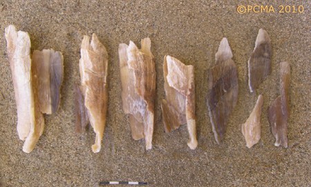
Archaeobotanical studies identified the wood and organic remains (leaving out the charcoal). The largest group by far is cedar wood Cedrus atlantica ssp. Libani, which is present mainly as chips or thin shavings in practically all the trenches. This form resulting from mechanical processing of the wood suggests that the wood was waste from a carpenter’s or shipwright’s workshop. The waste wood included also pieces of imported luxury wood, like the African iron tree Dahlbergia melacoxylon, and myrrh Boswellia carteri, possibly indicating that these species were also worked in the local workshops. Single pieces of pine wood Pinus halepensis and olive wood Olea europaea were found in trench BE10-59.
Many of the samples contained resin and plant gums. Four different types were distinguished on the grounds of organoleptic and physical characteristics. Samples have been submitted for biochemical analysis.
The Late Roman trash dump in trench BE10-59 provided the richest set of botanical remains, most significantly tamarisk and cedar wood fragments, seeds of the Phoenix dactylifera palm and of sisyphus Ziziphus spina christi, almond shells, also leaves of leek Allium porrum, laurel Laurus nobilis, lettuce Lactuca sativa and sycamore fig Ficus sycomorus, coriander Coriandrum sativum, Avena fatua and seeds of cucumber Cucumis sativus. The Early Roman rubbish added to this list a few more species: bulbs of garlic Allium sativum, seeds of sage Salvia aegyptica, and grass Desmostachya bipinnata.
The metal specialist and conservator in one concentrated on a selection of the 1450 fragments found this season (in addition to last year’s collection), including a copper dish (diameter 22 cm). The underside of this dish proved to have a raised decoration, possibly with a leaf- or flower pattern. Three iron “nails” equally divided along the edge of the dish were clamps for a (wooden) lid, of which traces were still visible, and/or the remnants of an iron tripod. Copper nails represented by far the largest group, followed by fish hooks. Other finds included arrowheads, box mountings and edge protectors, tools, and elements of personal adornment (rings), as well as a copper casket key.
The paper thin crescent-shaped silver objects hoarded in a pot in the temple [see Fig. 9 above] can be divided into four categories, of which the smallest ones weigh only 0.5 g, and the largest 1.5 g. The objects were possibly dedications nailed to wooden boards. Some of the smallest objects were partly covered in charred wood. It seems likely that these small silver decorative dedications were collected after a fire damaged the shrine in which these dedications had been placed.
Of the coins, apart from the above-mentioned Ptolemaic aes in good condition, there was a small bronze coin with a bust in a lunate-shaped crown on the obverse. This parallels some Aksumite issues, but the reverse remains unidentifiable. It could be a barbarous copy of some Aksumite coin or other prototype.
Glass and pottery studies were carried out on site on the newly excavated material and continued during a two-week period at the storeroom in Quft on material from the last season before the break in 2001.
Survey in the Eastern Desert
Two weekend forays into the Eastern Desert resulted in a few sites of different character being localized and documented. One of these is an ovoid-shaped burial enclosure, 19 m N-S by 21 m E-W, in Wadi Khashab [Fig. 19].
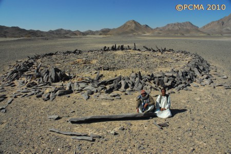
The site comprises a core of smaller cobbles and boulders with entrances on the southeastern and northern sides, and a series of pointed, relatively long (the longest preserved piece is 1.40 m long) and narrow upright stones preserved around the perimeter. Bones of longhorn cattle were discovered in one of the robber holes, but other burials appeared to be undisturbed. Satellite concentrations of long pointed stones, one of these measuring 3.23 m, may have been erected as obelisk-like dedications around the enclosure. No pottery was recorded from the site and dating at this point is controversial, though it may represent a Neolithic cattle cemetery.
Acknowledgments
The success of the season was certainly due to the determined and imaginative attitude of Dr. Mohamed Ismail, new head of the SCA’s Foreign Archaeological Mission Affairs Department, and his staff. Without their assistance, and the kind support of SCA’s Secretary General, Dr. Zahi Hawass, we could never have done as much as we did in the time set for the project. Not the least, Michał Neska of the PCMA Research Center in Cairo, freshly returned to his job at the Centre, was instrumental in fighting through all the formalities on the Cairo side and our SCA inspector, Amer Gad el-Kareem, on the Red Sea side. As ever, the Project owes a debt of gratitude to the local Ababda Bedouin and especially Mohamed Oudid and our various Egyptian friends, especially Ahmed Abd El-Mohsen.
Last but not least, there are our benefactors to thank: The John Seeger Foundation; the Institute for the Study of the Ancient World, NYU; Steven E. Sidebotham; Jean and Thomas Sidebotham, and others for financial support; the PCMA Research Center in Cairo for logistics, equipment and accommodations in Cairo; and the Institute of Prehistory, Adam Mickiewicz University in Poznań, for the loan of a Total Station instrument.
For a brief review of three seasons at Berenike, see the article in the newest issue of Sahara 21 (2010).
[Text: I. Zych and S. Sidebotham]
For seasons between 1994 and 2001 by the University of Delaware (USA) and Leiden University (the Netherlands), see
http://www.archbase.com/berenike/english1.html