Berenike (Egypt)
BERENIKE PROJECT
University of Delaware – PCMA expedition
Sub-projects: Wadi Khashab Projec
Wadi Gemal/Sikait Survey
The Wadi Khashab Project, 2012
(part of the larger Berenike Project)
Discovering a prehistoric cattle cemetery in the Eastern Desert
Digging dates: Three days in January 2012
Team:
Piotr Osypiński, archaeologist, head of the WK Project (Patrimonium Foundation)
Marek Woźniak, archaeologist/documentalist (PhD candidate, Institute of Archaeology and Ethnology, Polish Academy of Sciences)
Bartosz Wójcik, archaeologist/photographer (independent)
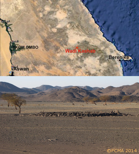
The site of Wadi Khashab (GPS coordinates N24º19’23,98” E34º31’28,64”) was observed in satellite photos and located on the ground for the first time by Prof. Steven E. Sidebotham and Dr. James A. Harrell during their survey of the Eastern Desert for the Berenike Project [Fig. 1].
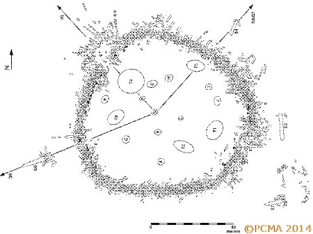
In 2010 the site (see Nesletter 2010) was visited by a team from the Berenike Project, surveying and fieldwalking the remains. At this time the site was measured with a tachymeter and a general plan was drawn [Fig. 2], photographs were taken and a general description made, including documentation of bones of apparently primigenous cattle from one of the grave features. It was interpreted provisionally as a prehistoric cattle cemetery. No ceramic material was noted anywhere on the surface or within the robber pits. Steps were taken to obtain an excavation permit and in 2012 a team headed by Piotr Osypiński, working under the auspices of the Berenike Project, returned to the site to carry out the first thorough inspection of the remains and the immediate surroundings, complete the documentation of the main feature and the satellite features, and test the main site archaeologically.
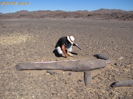
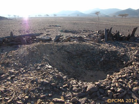
The first task was to define particular elements of the site and to search for their functional interrelations. The main component of the complex is the animal cemetery surrounded by megalithic steles [Fig. 3]. The main enclosure is a large ovoid feature approximately 18 m in diameter (visible in satellite photos). Inside the enclosure there were numerous robbery pits (designated as T1–T5 and A–J) and related dumps from which animal bones were recovered. These were identified already in 2010 by the Berenike Project’s archeozoologist Dr. Marta Osypińska as primigenous cattle typical of prehistoric sub-Saharan Africa, today found in southern Sudan and Kenya. The enclosure was formed of long pieces of slate rock set upon end or obliquely leaning to the inside, the longest of these measuring 2 m. The enclosure was destroyed in two places and the rocks dispersed over a radius of about 5 m. There were also stone steles over 2 m long (marked as S1–S5; the longest was 3.23 m long), all of them apparently deliberately toppled and even moved from their original positions by a few meters). Diverse other concentrations of destroyed steles and paved stretches (marked as S6–S10) were observed within a radius of 200 m.
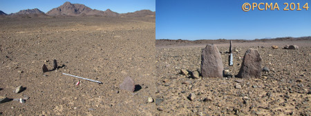
A smaller enclosure of the same type (S9), surrounded by steles of smaller size, was recorded about 70 m to the northwest of the main complex [Fig. 4]. At the northwestern fringes of the smaller complex of steles lay five stone pavements (P1–P5) of oval shape, approximately 1.00 m to 1.50 m across and one larger one (P6) situated about 30 m to the north of the others [Fig. 5]. These pavements resemble tombs in the Eastern Desert tradition, generally dated to the 5th century AD. A curious set of three steles still in place was noted about 100 m to the northwest of the smaller round enclosure [Fig. 6]. Surrounding this feature and scattered throughout the area were remains of modern Bedouin occupation [Fig. 7]. All the features of ancient date appear to be aligned on one axis. Four megalithic steles are situated in line with the smaller round enclosure, the pavements and the set of three steles, but on opposite sides of the main cemetery complex [see Fig. 2]. The satellite steles around the main enclosure, some of which were more than 2 m high, were also aligned, the axis cutting the circular enclosure from southeast to northwest. The orientation may be of symbolic or functional significance, although it could also be related to ground relief as all of them appear to stand on small rises in the ground (the difference of height with regard to the wadi bottom can reach up to 1 m).
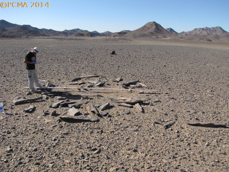
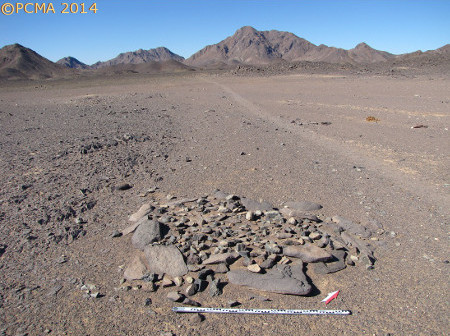
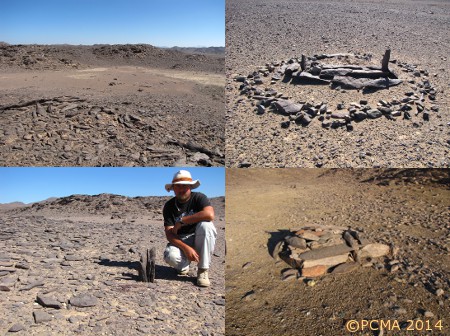
Two test trenches in the main complex were excavated; they were 1 m wide and, combined, gave a total length of 18 m, permitting an analysis of feature stratigraphy [Fig. 8]. Sterile layers were reached at a depth from 15 cm to 54 cm below the present surface. The fill comprised rock debris which must have originally formed the mounds above particular graves; repeated plundering of the graves has left little trace of these original mounds. The trenches encompassed also two evident robbery pits, one of which had produced a collection of cattle bones noted in a previous report from the 2010 Berenike Project season.
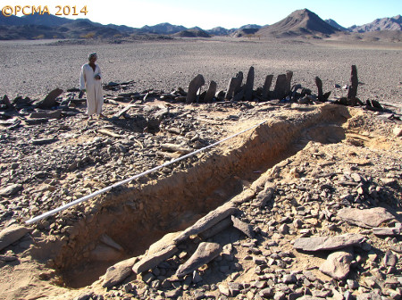
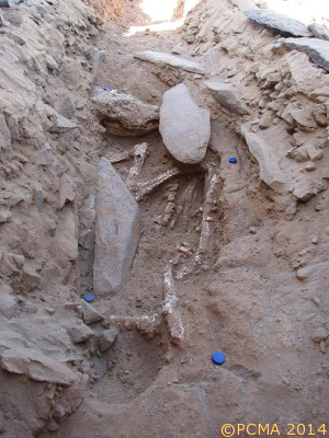
The present work uncovered yet another burial (Burial 1) where the plundering seems not to have reached the level of the skeleton. The pit was roughly rectangular, about 2 m long and 1 m wide, oriented SE–NW. The animal skeleton lay on its left side, head to the northwest [Fig. 10]. The pit was filled with soil mixed with greenish pebbles and covered with flat stone slabs. Smaller stones may have formed a mound above the grave. Analysis of the other two burials revealed elements of construction similar to Burial 1.
No archaeological material capable of dating the complex was found. Some residual pottery from the surface around the complex has been placed tentatively in the late Ptolemaic–early Roman age. The animal bones are heavily eroded. They were covered with cloth and the pit backfilled with sieved sand.
The complex at Wadi Khashab has few close parallels, not only in the Red Sea region, but also broadly speaking in the entire Eastern Desert. The nearest analogies come from the Nile Valley where remains of primigenous cattle have been present in funerary ritual from the Neolithic through the period of the kingdom of Kerma. Whole animal interments are rare. The Wadi Khashab cemetery appears to have been constructed all at once and the presence in the neighborhood of stone circles and megalithic steles suggests its ceremonial character.
Further work should concentrate on exploring other burials in the cattle cemetery in order to pinpoint a dating for the site and to survey the immediate surroundings of the site to see whether it fitted into a more universal network of similar sites in the Eastern Desert.
[Text: P. Osypiński]