Pelusium (Tell Farama) (Egypt)
Reconstructing the layout of Pelusium
Dates: 3-9 May 2009; 3-8 May 2008; 12-18 October 2005
Team:
Tomasz Herbich, project head (Institute of Archaeology and Ethnology, Polish Academy of Sciences)
Artur Buszek (2008, 2009), Michał Kurzyk (2005), Szymon Maślak (2005, 2008), Dawid Święch (2005, 2008, 2009), Robert Ryndziewicz (2009), Szymon Zdziebłowski (2009)
Geophysical mapping of the area inside the northern limits of the town, conducted from 2005 as part of a research project in the Polish concession, developed into a full-scale geophysical prospection project within the framework of a broader study aimed at reconstructing the urban layout of sites in the Nile Delta based on the results of geophysical research. The present fieldwork was the third season of the geophysical survey (which has taken up no more than a few days at a time). Close to 9 hectares have been mapped by the magnetic method (parallel mode, grid 0.25 x 0.50 m) and some 4.5 hectares by the resistivity method (grid of 0.5 x 1 m, twin probe 0.5 m). It turns out that this is a biggest single area tested by the resistivity method anywhere on an archaeological site in Egypt. The fieldwork will be continued until the entire part of ancient town west of the Roman fortress and east of Tell Mahzan has been mapped.
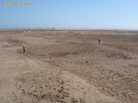
Pelusium (modern Tell el-Farama) in northwestern Sinai stood on the Mediterranean shore at the mouth of the now extinct Pelusiac branch of the Nile. The town, which was at its heyday in Ptolemaic and Greco-Roman times, was the most important harbor in Egypt after Alexandria. It existed until the medieval age when it was destroyed and abandoned. Some ancient ruins and the walls of a Late Roman fort could still be seen in modern times. Excavations in the 20th century uncovered the building of a bath, the foundations of a theater and a church — altogether no more than 2% of the area of the ancient town. The site was not inhabited again until modern times and is for the most part flat due to erosional processes [Fig. 1]. The ruins, mostly of red brick which is strongly magnetic, are found immediately below the ground surface. The substrate is alluvial in nature, humid and salty due to the nearness of the sea; it is therefore an excellent electrical conductor. Owing to these factors Pelusium is a perfect site for geophysical research, whether by the magnetic or by the electrical resistivity methods. The abundance of written sources concerning the town creates an excellent opportunity for confronting the results of geophysical mapping with historical references.
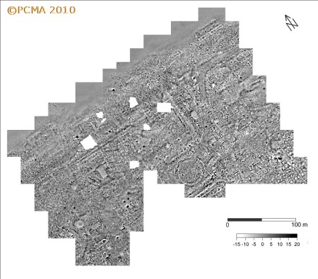
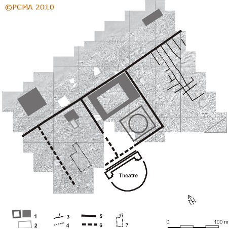
Geophysical prospection by the magnetic method within the fortress walls was undertaken by an Egyptian team in the 1990s (E. H. Ibrahim, M. R. Sherif, A. A. Al-Metwally, Shallow geophysical investigations on Tell el-Farama, Northwest Sinai, Egypt, Archaeological Prospection 5, 91–100), but the results were too indistinct for any conclusive reconstruction of the layout. Higher sampling density in the magnetic survey and appropriate choice of depth range in the electrical resistance measurements, applied by the Polish team working on the site since 2005, have demonstrated the potential of geophysics for reconstructing with full reliability large sections of the town plan. A district of monumental architecture was mapped by the magnetic method in front of the theater [Fig. 2]. The extent of the district was established, a habitational district was recorded and the street grid, as well as the size and layout of individual buildings were traced. The survey also allowed the borderline between the city and the lagoon to be determined. The most intriguing structure discovered by the magnetic survey is a square building with round central chamber almost 35 m in diameter [Fig. 4]. This building may have been the town’s bouleuterion (Krzysztof Jakubiak, Tell Farama, Pelusium. City urban planning reconstruction in the light of the last researches [in:] Proceedings of the Fifth Central European Conference of Egyptologists. Egypt 2009: perspectives of research. Pułtusk 22–24 June 2009, J. Popielska-Grzybowska and J. Iwaszczuk (eds), Acta Archaeologica Pultuskiensia 2, Pułtusk 2009, 65–74).
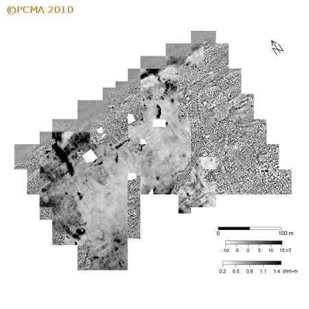
The electrical resistivity survey has helped to clarify the plan of a number of structures mapped by the magnetic method [Fig. 3]. An integrated approach to the prospection made it possible to identify the building material, whether red brick, mud brick or stone. In a number of cases, combined analyses of magnetic and resistivity images indicated which linear anomalies on the magnetic map reflected structures and which the spaces between structures. This was instrumental for a reliable location of individual features.
[Text: T. Herbich]